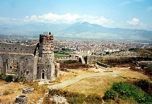
Rozafa castle (Albanian: Kalaja e Rozafës) is a castle near the city of Shkodër, in northwestern Albania. It rises imposingly on a rocky hill, 130 metres above sea level, surrounded by the Bojana and Drin rivers. Shkodër is the capital of the District of Shkodër, and is one of Albania's oldest and most historic towns, as well as an important cultural and economic centre.Due to its strategic location, the hill has been settled since antiquity. It was an Illyrian stronghold until it was captured by the Romans in 167 BC. The 19th-century German author and explorer Johann Georg von Hahn suggested that the ancient and medieval city of Shkodër was located immediately south of the Rozafa hill, between the hill and the confluence of Buna and Drin. The fortifications, as they have been preserved to date, are mostly of Venetian origin. The castle has been the site of several famous sieges, including the siege of Shkodra by the Ottomans in 1478 and the siege of Shkodra by the Montenegrins in 1912. The castle and its surroundings form an Archaeological Park of Albania.
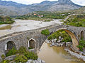
Mes Bridge (Albanian: Ura e Mesit "bridge in the middle") is a bridge in the village of Mes, about five kilometres (straight line) northeast of Shkodër, in northwestern Albania. It was built in the 18th century, around 1780, by Kara Mahmud Bushati, the localOttoman pasha,[1] and it spans the Kir River.It is 108 m long, and represent one of the longest Ottoman bridges in the region.[4] It was built as part of the road that goes up the Kir Valley, eventually to Pristina.
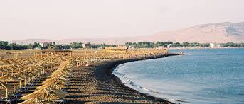
Velipoja is situated on the estuary of the River Buna (the only navigable river of Albania), where it flows into the Adriatic Sea while making border with Montenegro. The Commune(i.e. the administrative unit) of Velipoja has a population of around 10,000, spread over several small settlements, the largest of which is the town of Velipoja itself.
Its economy is based on agriculture (arable land and livestock, sheep and cattle), some fishing, and chiefly tourism. The scenery is largely unspoilt: a mixture of sea-coast, river estuary, heathland, thick pine woods, farmland, and high mountains. It has been remarked by visitors that the heathland to the north of Velipoja is very reminiscent of Scottish scenery. A nature reserve lies within the commune. The area is a prime site forbirdwatching, game shooting and fishing. A long, sandy beach with a seaside promenade is a popular attraction in summer.
In recent years, several projects have been instituted with the aim of conserving the environment (including the marine life of the Buna) and the encouragement of ecological tourism. There have also been recent efforts to develop fish farming. The area has many small hotels and guest houses. There is a market, where local farmers sell their produce. In the commune, there is a church-sponsored kindergarten, several primary schools, two secondary schools, and one gymnasium. There is also a small theatre and a thriving local football team, KS Ada Velipojë and ground.
Fierzë-Koman-Fierzë Line Ferry, also known as Lake Koman Ferry is a passenger ferry service operated by several local companies along the Koman Reservoir (also known as Koman Lake) in Northern Albania. The line operates between Koman near the Koman Hydroelectric Power Station and Fierzë near the Fierza Hydroelectric Power Station. According to Bradt Travel guides, the journey is described as "One of the world's great boat trips" only comparable to the Scandinavian fjords.
The old car ferry ship underwent a complete makeover and began regular trips in May 2015 with the new name Alpin Ferry.Between June 2012 and April 2014 the car ferry was no longer running. The new A1 highway connecting the Albanian coast with Kukes and Kosovo made it redundant and allowed for the ship makeover. Meanwhile, a small, boat converted bus operated on the same route. Presently, several private tours have begun operations offering custom tours packages with acceptable small vessels.
The line is known for its breath taking views of the mountain gorges, unscheduled stops along the way for serving locals, and the peculiar atmosphere of both locals, foreigners, and even animals being fitted on board up to full capacity.
ALBANIAN ALPS
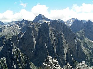
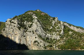
Prokletije or the Albanian Alps (Albanian: Alpet Shqiptare, meaning "Albanian Alps", or Bjeshkët e Namuna; is a mountain range on the Balkan peninsula, extending from northern Albania to Kosovo and eastern Montenegro. Its peak in Albania, Maja Jezercë at 2,694 m (8,839 ft), is the highest point of the Dinaric Alps, and the 7th highest peak in Albania.
Both the highest peak in Montenegro, Zla Kolata at 2,534 m (8,314 ft) (which is also partially in Albania) and the highest in Kosovo, Đeravica at 2,656 m (8,714 ft), are located here. The highest peak in Albania, however, is Mount Korab, part of theKorab range, at 2,764 m (9,068 ft) high and located in the east of the country on the border with the Republic of Macedonia(making it Macedonia's highest point in addition).
The southernmost glaciers in Europe were recently discovered in the Albanian part of the range. The regional economy is based mainly on agriculture, immigrant remittances and tourism.
Canyons and Valleys
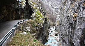
The erosion of the Prokletije mountains by glaciers left many telltale features behind. Deep river canyons and flat valleys wind around the ridges of the mountains. The largest and most popular canyon is Rugova Canyon. It is situated in Kosovo and is 25 km (16 mi) long from the border with Montenegro to the city of Peć and is 1,000 m (3,281 ft) deep. It has very steep vertical mountain slopes on both sides.
Valleys common at lower altitudes are also found at the alpine level, creating mountain passes and valley troughs. The most well-known valley to be high up in the mountains is Buni Jezerce in Albania. Buni Jezerce means "Valley of the Lakes" and it contains six small glacial lakes, the biggest being called the Big lake of Buni Jezerce.
Valleys common at lower altitudes are also found at the alpine level, creating mountain passes and valley troughs. The most well-known valley to be high up in the mountains is Buni Jezerce in Albania. Buni Jezerce means "Valley of the Lakes" and it contains six small glacial lakes, the biggest being called the Big lake of Buni Jezerce.
